The Devil's Tower is one of the most unique rock formations in the country. Known as a butte, the hill formation features steep sides and a relatively flat top. It is composed of igneous rock that formed hundreds of millions of years ago but how it formed is unknown to geologists. There are modern theories, however, that it was likely formed by igneous intrusion, which occurs when magma penetrates an existing rock and solidifies from underground.
Located in Crook County, the Devils Tower is the first national monument in the US, established by Theodore Roosevelt in 1906. Although Native Americans have had other names for this landmark, the name Devil's Tower originated from Colonel Richard Irving Dodge when he discovered it in 1875.
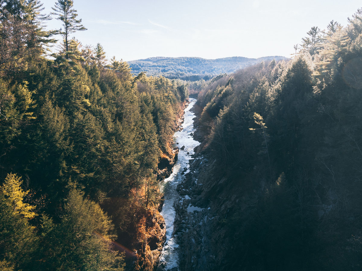
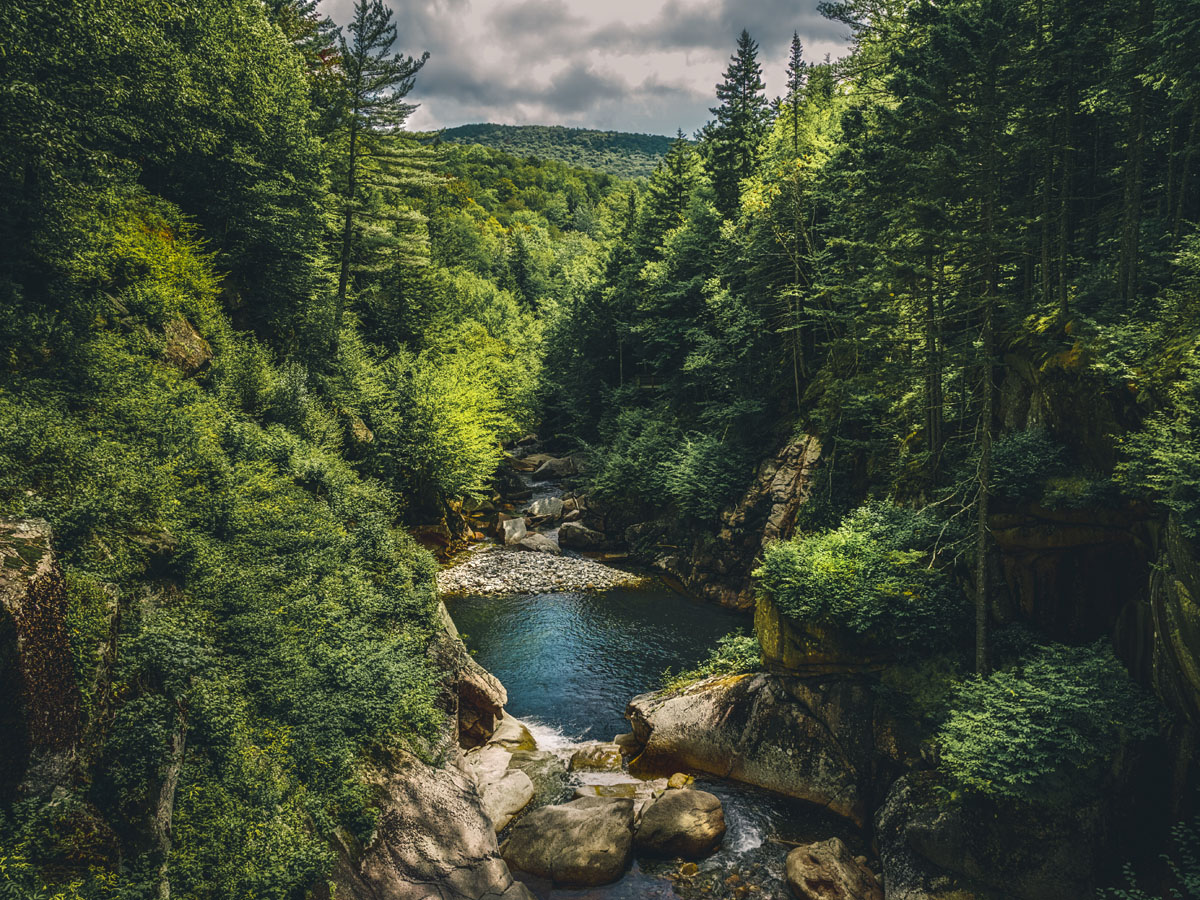
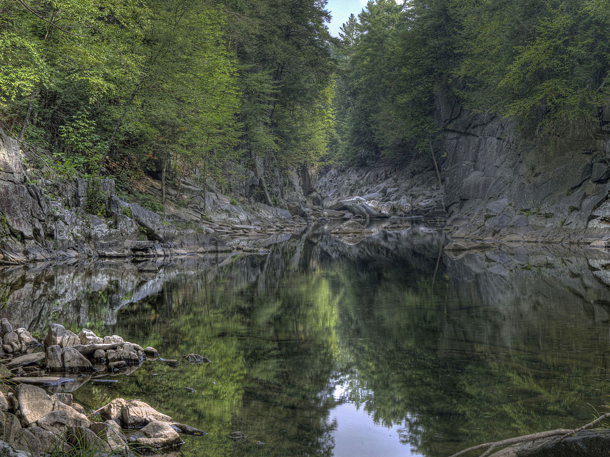
Quechee Gorge is one of the most popular spots in Vermont. The Quechee Gorge State Park area offers stunning views of the gorge, which can be seen from the U.S. Route 4 bridge and via trails in the area. It is extremely popular among the people of New England. The Ottauquechee River flows through the gorge and is a great spot for kayaking.
The Quechee Gorge is approximately 13,000 years old and is believed to be carved out by the Laurentide Ice Sheet that was present millions of years ago and slowly retreated. It is among the deepest gorges in the country and the deepest in Vermont at 165 feet.
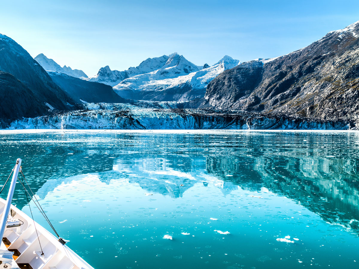
The Glacier Bay National Park and Preserve encompasses a massive area of 5,037 square miles. On the west side of the bay are the Paleozoic sedimentary rocks that are approximately 26,000 feet thick and made up of limestone and argillite. The Glacier Bay Basin features surrounding mountains and jaw-dropping views of glaciers. There are an estimated 1,045 glaciers in the area, and the most popular means of viewing Glacier Bay is by cruise ship.
Glacier Bay was initially proclaimed a national monument by President Calvin Coolidge in 1925. The area was expanded in 1978 by Jimmy Carter, and then further with the Alaska National Interest Lands Conservation Act in 1980. This protects not only the vast natural landscape but the fauna as well. Wildlife in the area includes two species of bear, wolves, the black-tailed deer, multiple hawk and falcon species, and the humpback whale among many others.
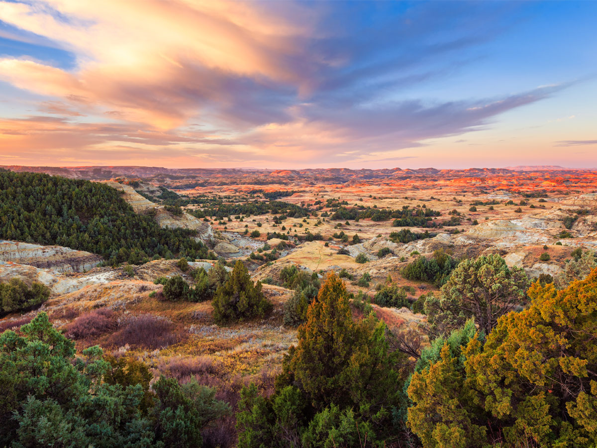
The Theodore Roosevelt National Park in the western part of North Dakota is comprised of three separate badlands which altogether stretches out over 110 square miles. It is a popular area for viewing wildlife as it is inhabited by bison, coyotes, prairie dogs, bighorn sheep, turkeys and golden eagles. The area features a wheatgrass prairie landscape and Floodplain Forests in the northern part of the park.
The area first caught the eye of Theodore Roosevelt in 1883 when he was searching for bison hunting spot. He would fall in love with the area and purchase Maltese Cross Ranch. By 1947, the area would become the Theodore Roosevelt National Memorial Park at the behest of President Truman and in 1978 was renamed the Theodore Roosevelt National Park.
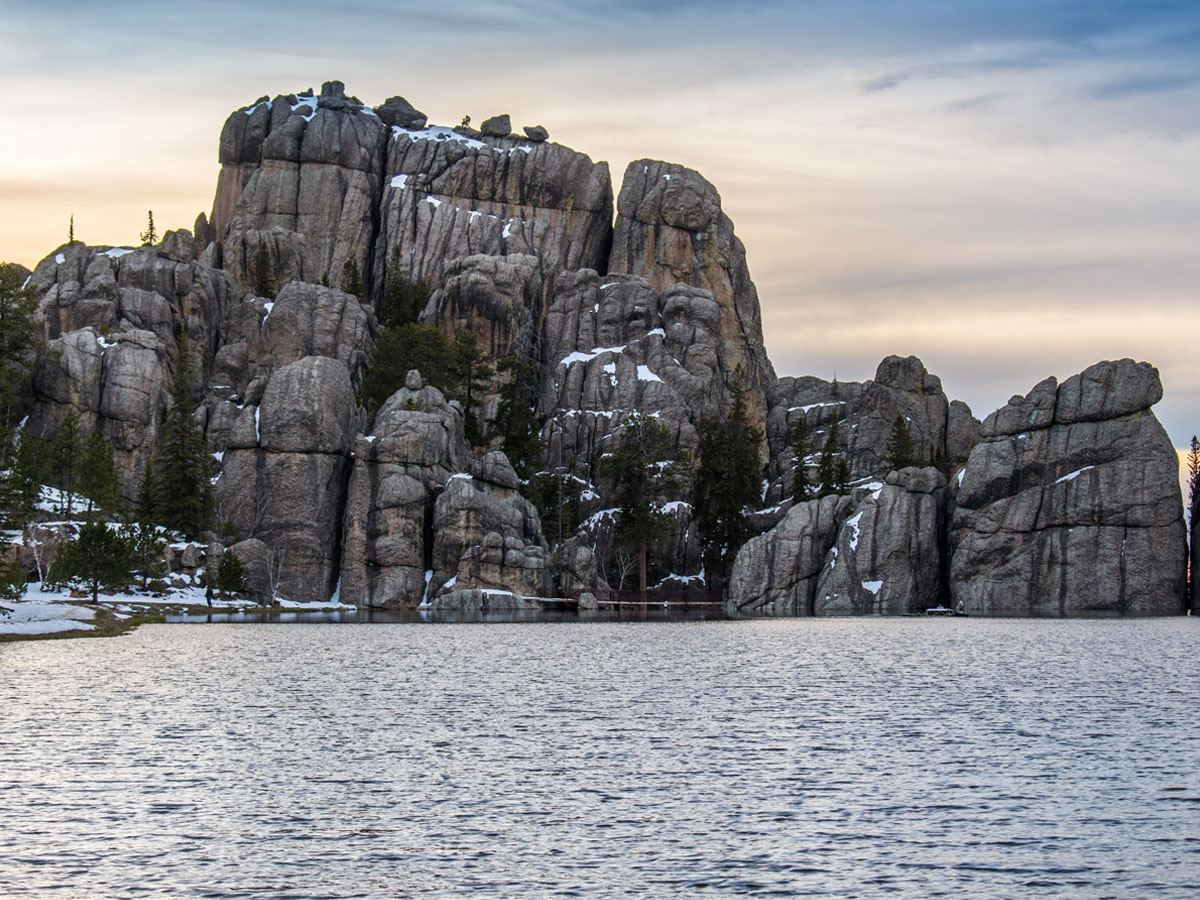
Speaking of Bison, Custer State Park is home to over 1,500. The vast wildlife reserve features rolling prairie grasslands and a rugged mountain range. In addition to bison, you'll find multiple species of deer, mountain goats and even river otters. There are also cougars in the area, but you don't see them; they see you.
Custer State Park is the state's first and largest park. It was named after the infamous Lt. Colonel George Armstrong Custer. The park covers an area of 71,000 acres. You can enjoy the area by foot or take a scenic drive through Needles Highway. Popular activities in the area include camping, hiking, fishing, swimming and biking.
Brandywine Creek, located in Northern Delaware, is 20.4 miles long. The picturesque creek is surrounded by a lush forest. The Brandywine Creek State Park is divided by a massive stone wall that was built in the 19th century by the du Pont family. Nearby, you'll find Tulip Tree Woods and Freshwater Marsh.
Before the du Pont family purchased the property, the Brandywine Creek area was inhabited by Native American tribes and then by European settlers in 1638. Later the creek would become a revolutionary war battlefield in the 1777 Battle of Brandywine where General William Howe defeated George Washington's forces. Here, history meets nature.
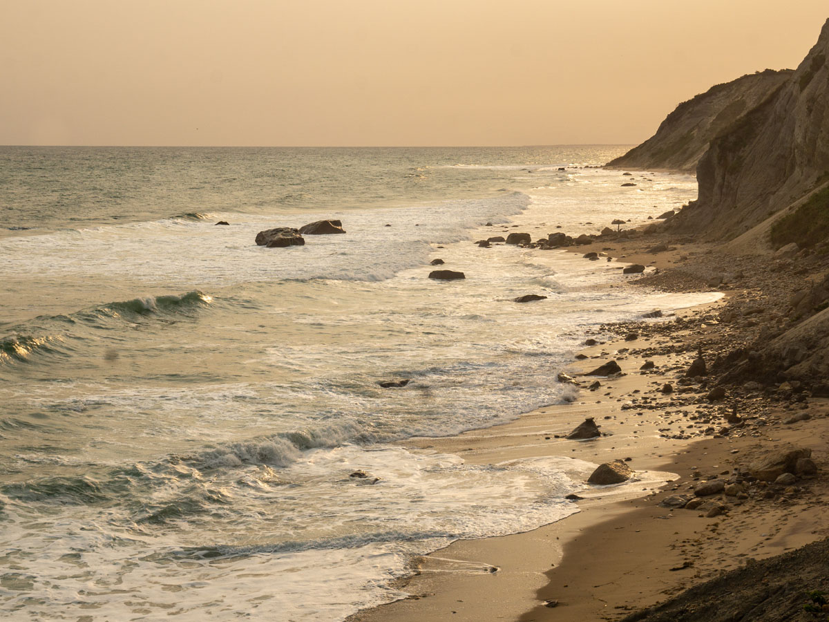
The Mohegan Bluffs in Rhode Island are among the most breathtaking cliffs in the country. Made up of clay, the cliffs are about 150 feet high and can be found on the shore of Block Island. The cliffs provide an expansive view of the Atlantic Ocean and a beautiful view of the sunset.
The Mohegan Bluffs are named after a battle between the Niantic and the Mohegan tribes that occurred in the 16th century. During this battle, the Mohegan tribes were flung off the cliffs by the Niantic. Over the years, the Mohegan Bluffs have eroded significantly, as much as 250 feet. In fact, they have eroded so much that the Block Island Southeast Lighthouse was moved back 360 feet to prevent it from collapsing into the ocean.
Not to be confused with Glacier Bay in Alaska, Glacier National Park in Montana is located on the Canadian-American border. Glacier National Park spans over 1 million acres. It features two separate sections of mountain ranges, including the Rocky Mountains, over 1,000 species of flora and hundreds of fauna. Bask in the majesty of Saint Mary lake and the most well-preserved Proterozoic sedimentary rocks in the world. Hiking and fishing are popular activities in the area.
Although Glacier is in the name, over the last 12,000 years, the glaciers of Glacier National Park have largely disappeared. While 150 glaciers existed in the mid-19th century, only about 25 exist now. The mountains in the region formed over 170 million years ago. Like most areas in the country, it was first inhabited by Native American tribes until European settlers arrived.
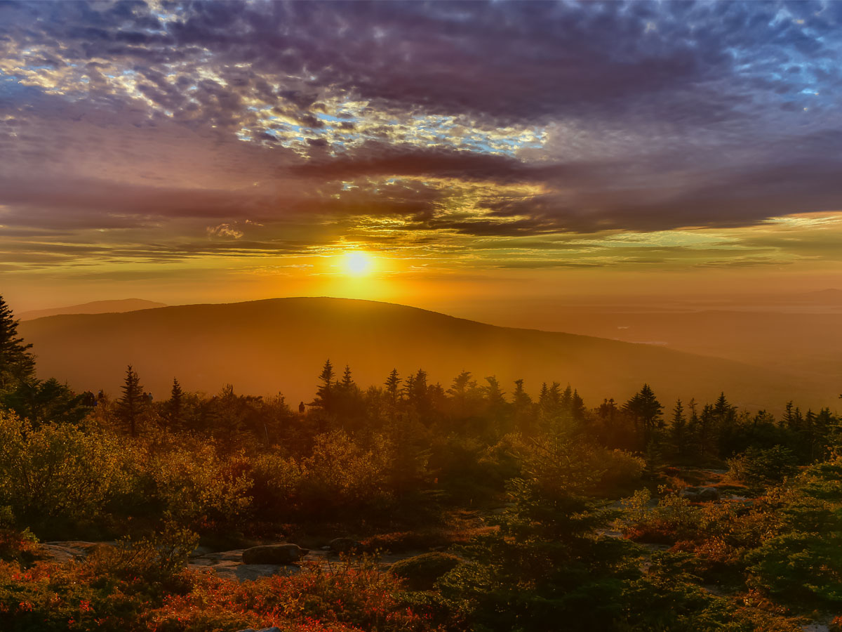
Cadillac Mountain at Acadia National Park in Maine, is easily one of the most gorgeous sites in the state. At an elevation of 1,530 feet, Cadillac Mountain is the highest point in Hancock County. During certain times of the year, it is the first place to see the sunrise in the US.
Up until 1918, Cadillac Mountain was referred to as Green Mountain. However, it was changed to honor a French explorer, Antoine de La Mothe Cadillac who arrived in North America in 1683 and founded new France. Sorry, if you thought Cadillac Mountain was named after a car.
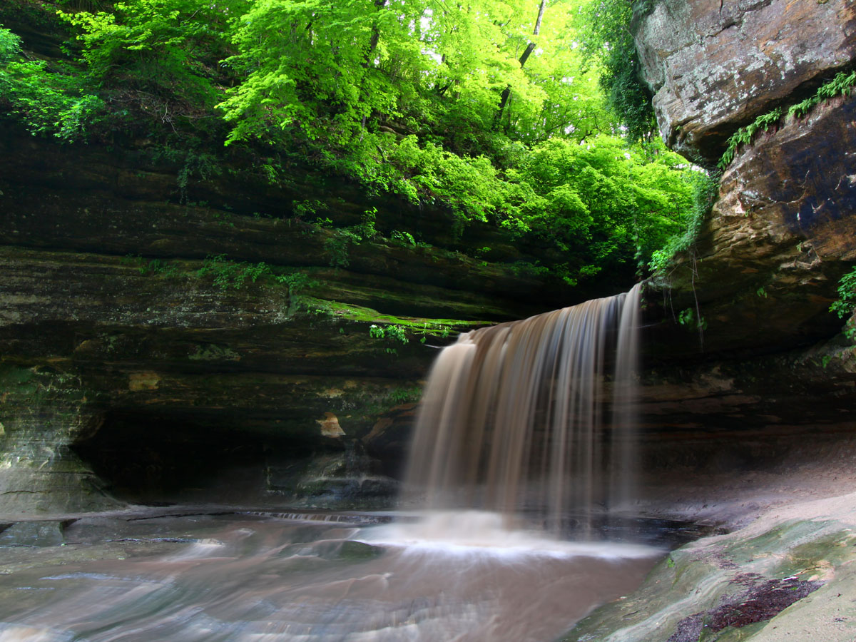
Flume Gorge is one of the most eye-opening gorges in the country. The natural gorge stretches 800 feet at the base of Mount Liberty. Its wall is made up of Conway granite and go up to 90 feet high. The width of the gorge varies from 12 feet to 20 feet. If traveling through the gorge loop, it will take you up to 1.5 hours on foot. A manmade path includes lots of stairs, so make sure you get in shape.
The Flume Gorge granite is believed to be over 200 million years old. It was once buried molten rock that was cooled and broken by vertical fractures. Following these fractures, dikes of basalt forced the granite apart. Erosion then worked to expose the dikes, slowly forming the valley as it appears now.
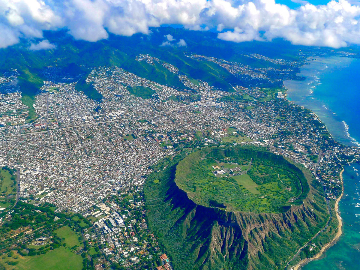
Of all the wonders of Hawaii, Diamond Head would have to be one of the most recognizable. But if you don't know, it’s a volcanic tuff cone located on the island of O?ahu. Tourists and residents of Waikiki continue to marvel over this natural wonder. A trail that goes to the top of the cone takes about 45 minutes. It's not a particularly difficult trail but it is a workout nevertheless.
Since 1968, the Diamond Head is proclaimed a National Natural Landmark. For those who are concerned about eruptions, fear not, because Diamond Head is monogenetic, which means that eruption can only occur once. Fortunately for you, the last eruption happened over 150,000 years ago.

New River Gorge is one of the oldest rivers in North America. The surrounding New River Valley is comprised of 70,000 acres of land. Breathtaking whitewater rapids make this site an ideal place for those who enjoy rafting. The New River Gorge also features popular climbing areas with over 1,400 recorded climbs. The area is also brimming with wildlife - at least 63 different mammals and rare species like bats.
The New River Gorge National River was established in 1978 by Jimmy Carter. Located in the Appalachian Mountains, the Gorge features 50 miles of hiking trails. It also has some relaxing fishing spots where you can really wind down.

This natural wonder is a protected volcanic area with the best-preserved flood basalt in the country. Flood basalt occurs when a series of eruptions cover the area with basalt (mafic extrusive igneous rock) lava. Activities in the area include hiking trails, cave exploration, and even skiing during the winter.
Established in 1924, President Clinton expanded the Monument and Preserve by 2,000. The area is now comprised of three separate lava fields and covers 1,117 square miles. Water in the area is scarce but there are over 375 species of flora that grow. Animals get most of the water they need from the foods they eat. While it may be on Earth, visiting the Craters of the Moon is certainly an out-of-this-world experience.
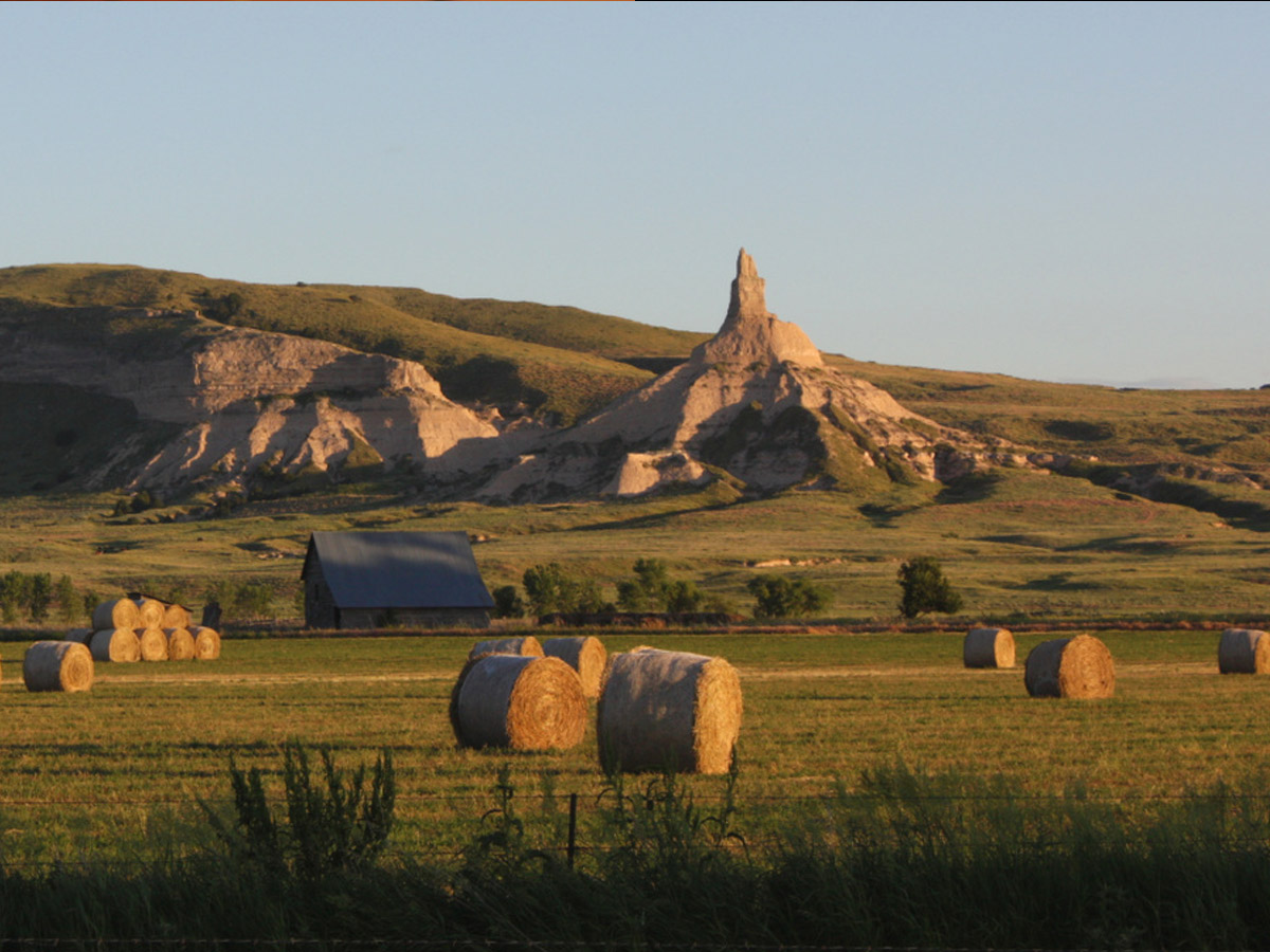
Chimney Rock in Nebraska is not only an impressive natural wonder but it's also a place of great historical significance. The rock formation consists of Brule clay, combined with volcanic ash and Arikaree sandstone. It is approximately 286 feet high and can be seen from U.S. Route 26 and Nebraska Highway 92.
Chimney Rock has long served as a notable landmark. Historically, it was part of the Oregon Trail, the California Trail, as well as the Mormon Trail. In 1956, Chimney Rock was designated a National Historic Site. Since then, it was featured on the Nebraska State Quarter along with a covered wagon. Significant indeed, Chimney Rock was a natural wonder that helped shape the country.

White Sands National Park is one of the most fascinating locations in the world. Located in Otero County and Doña Ana County, the White Sands National Park is comprised of white sand dunes made of gypsum crystals. It is the largest of its kind. The desert stretches 275 square miles. Preserved in the dune fields are human footprints and animal prints from over 10,000 years ago.
You can find White Sands National Park on U.S. Route 70 in the Tularosa Basin. In 1933, President Herbert Hoover designated it the White Sands National Monument and in late 2019, it was redesignated a national park. But years before it became a national park, it was an area filled with lakes, streams, grass and ancient mammals. Today you can find various cacti and succulents in terms of flora and over 800 different species of animals including birds, insects, arachnids, reptiles, and mammals.

Monument Rocks in Kansas is another one of the most notable landmarks in the country. It is made up of a series of chalk formations that are rich with fossils as far back as the Cretaceous Period (80 million years ago). Also called the Chalk Pyramids, they can be seen from the US-83 highway. While the Monument Rocks are located on privately owned land, the owners allow visitors during daytime hours.
Similar to Castle Rock, another Kansas landmark, Monument Rocks was formed from chalk deposited by an ancient sea, after which, wind and water eroded the chalk into what you can see today. Miles from any sources of light pollution, it's also worth noting that you can see the Milky Way in the night sky.
Casino owners have tried and failed to start developing the land and that's good news for you because it's the most exquisite spot in Mississippi. The Deer Island Coastal Preserve can be found off the coast of Biloxi. The secluded island is an ideal place for boating, canoeing, paddleboarding, swimming and whatever other water activities you prefer.
Deer Island consists of over 400 acres of land. The island offers exquisite views, a gorgeous landscape, and reportedly 10 different endangered species. And beyond the physical realm, many claim that Deer Island is haunted by metaphysical beings: the Headless Skeleton and the Firewater Ghost.
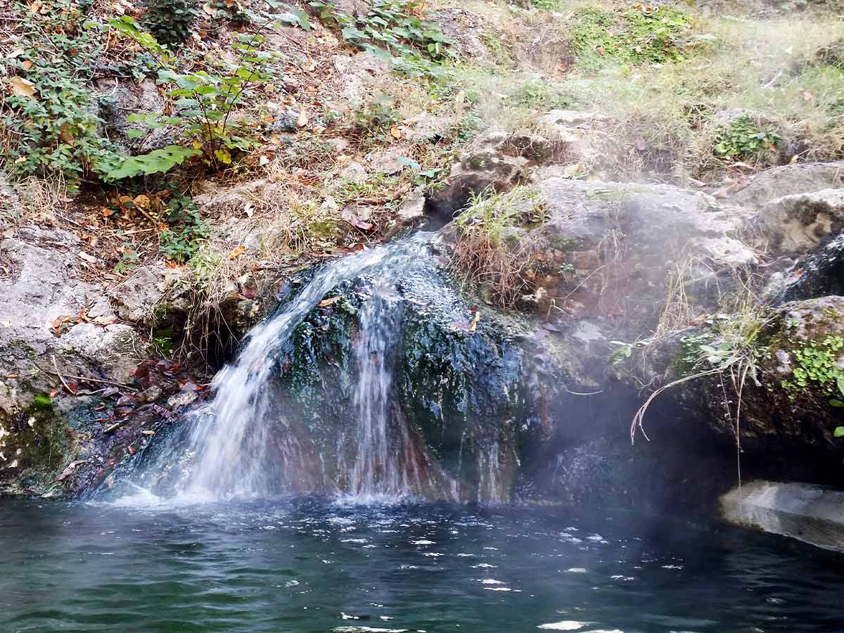
Searching for a relaxing spa? Only nature can offer the best, and at Hot Springs National Park, you can find the best spa in Arkansas. The ancient thermal springs are made up of geothermally heated groundwater that rises from the crust of the earth. The water can get as hot as 143 degrees Fahrenheit. Many believe these hot springs provide medicinal benefits, but at the very least, they sure are a relaxing spot to take a dip.
The Hot Springs in Arkansas was first designated as the Hot Springs Reservation. Preserved for recreational purposes, the Springs were reserved in 1832 by Congress before the idea of a national park was ever a thing. In 1921 it would become a national park. Today you can bathe in the hot springs, go hiking on over 26 miles of trails and find plenty of excellent camping spots.

Nevada may be most known for Las Vegas, a city that is anything but natural, but in Gerlach you will find the state's greatest natural wonder. Fly Geyser is made up of six-foot-tall geysers that, while naturally occurring, is actually rooted in human error. The bright red-colored geyser is covered in algae and spews water as high as five feet in the air.
Most geysers are rare phenomena that are basically erupting hot springs. They stop as soon as the water from the spring is depleted. Nevada's Fly Geyser in part, man-made. That's because residents in 1916, seeking irrigation water, drilled a well at the spot. When they discovered was too hot for drinking, they abandoned the well. Another geyser was created when a geothermal power company drilled a test well in 1964. Because the wells were not properly capped, water started erupting from the holes and calcium carbonate deposits began forming, thus creating Fly Geyser.

If you love exploring caves, you'll want to check out Maquoketa Caves State Park. The state park in Iowa contains numerous caves filled with limestone formations and bluffs. The caves are easy for travelers to explore and inside you can find many artifacts such as arrows, pottery, and tools. Native American tribes in the area and early European settlers are believed to have used the caves at one point or another.
The Maquoketa Caves State Park was first purchased in 1921 to create a state park. At the time it was called Morehead caves but was changed to Maquoketa Caves in 1928. By 1991 the area had been expanded to 323 acres.

The Narrows at Zion National Park would have to be the most fascinating place to explore in the area. Part of Zion Canyon, the section features a 3.6-mile hike from the bottom of the Temple of Sinawava to the top of Big Springs. Another hike takes you 16 miles from Chamberlain's Ranch back down to the Temple of Sinawava.
Flowing through the narrows is a cool, shallow river called the Virgin River. However, at certain times, the water levels may be higher from runoff and flood, which in that case, hiking is not allowed. Popular times for hiking the Narrows are the late spring and summer when the water levels are lowest. Explore this majestic canyon yourself and behold the wonders of mother nature.
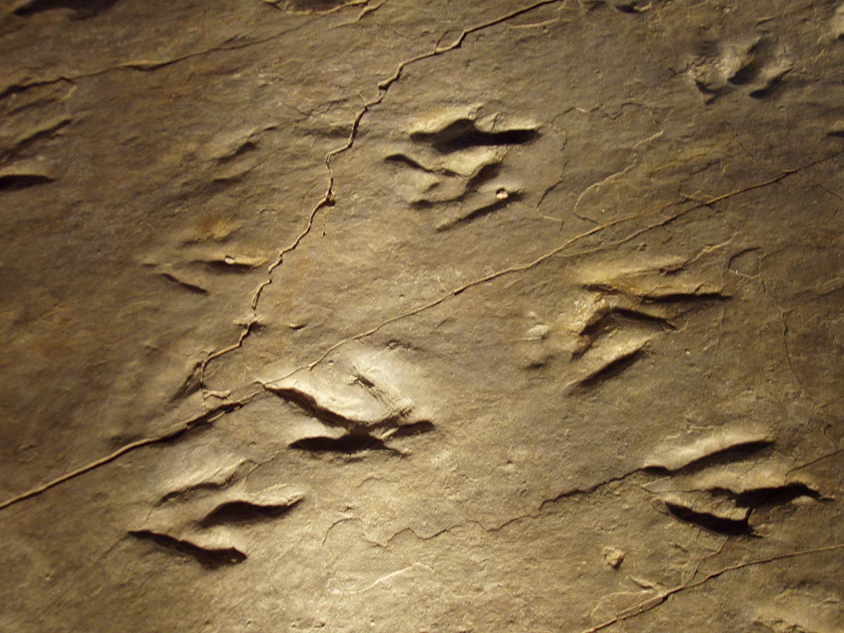
Dinosaur State Park in Rocky Hill, Connecticut encompasses 80 acres of land. The state park is home to preserved dinosaur track fossils that originate from the Jurassic period (200 million years ago). The Geodesic dome, which is 55,000 square feet, features 500 tracks for viewing. Meanwhile, 1,500 more tracks have been buried for the sake of preservation.
The Eubrontes tracks on display at the park are believed to belong to Dilophosaurus species. The Dinosaur State Park opened in 1968 - just two years after the prints were discovered. For kids that love dinosaurs this is an ideal location for families. The forest features hickory, oak and beech trees.

Who doesn't love a good waterfall? At Turner Falls Park in Oklahoma, you'll find Turner Falls on Honey Creek. At a whopping 77 feet tall, it is the tallest waterfall in the state. Guests can go for a swim in one of two pools, or take a hike nearby. The park allows for tent camping, RV camping or, otherwise, you can rent a cabin.
Turner Falls gets its name from Mazeppa Thomas Turner, a Scottish immigrant farmer who married Lauren Johnson, a woman of the Chicasaw Nation. The two lovers settled in Davis, Oklahoma and discovered the falls. At 1,500 acres, Turner Falls Park is not huge, but it’s a nice little spot to enjoy with your family during the summer.

If you really want to be adventuresome, you could always take a dip in a volcano. Well, that is to say - one filled with water rather than lava. Crater lake in Oregon is one of the most striking lakes in the Pacific Northwest. The lake is known for its deep blue color and clarity. The lake is massive with a surface area of 20.6 square miles and fills a volcanic crater that is 2,148 feet deep.
The crater of the lake is estimated to be around 7,700 years old, give or take, when the collapse of Mount Mazama occurred. While no rivers flow to or from the lake, Crater Lake replenishes slowly over time through snow or rainfall.

Mammoth Cave National park in Kentucky features the longest cave system in the known world. The cave primarily exists in Edmonson county and extends into Hart and Barren counties. It features over 400 miles of passageways. The national park service provides tours of the cave that range from one hour in length to six hours.
Mammoth Cave is made up of thick layers of Mississippian-aged limestone strata and a layer of sandstone. Inhabiting the cave are several species of bat. The cave has also been used since prehistoric times by people, as several Native American remains have been found in the cave and dated. Mammoth Cave National Park was established in 1941 and continues to be an intriguing tourist location for the adventurer-at-heart. Camping areas are available.
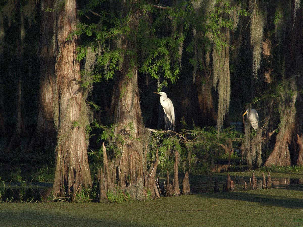
Louisiana is well-known for its many swamps in the area. They are a tourist hotspot where millions flock to experience the stagnant green water and the gentle hissing of the American Alligator. Just Kidding. The Atchafalaya River Basin is actually quite beautiful and is the largest floodplain swamp on the continent at nearly one million acres.
The Nature Conservancy of Louisiana has deemed that the Atchafalaya River Basin is actually among the state's most important habitats. The 5,000-acre Atchafalaya Preserve works as a flood relief outlet, and also provides filtration for the Mississippi River before the water enters the Gulf of Mexico. Surrounded by a rich forest and diverse wildlife, the Atchafalaya River Basin is truly a swamp worth exploring.
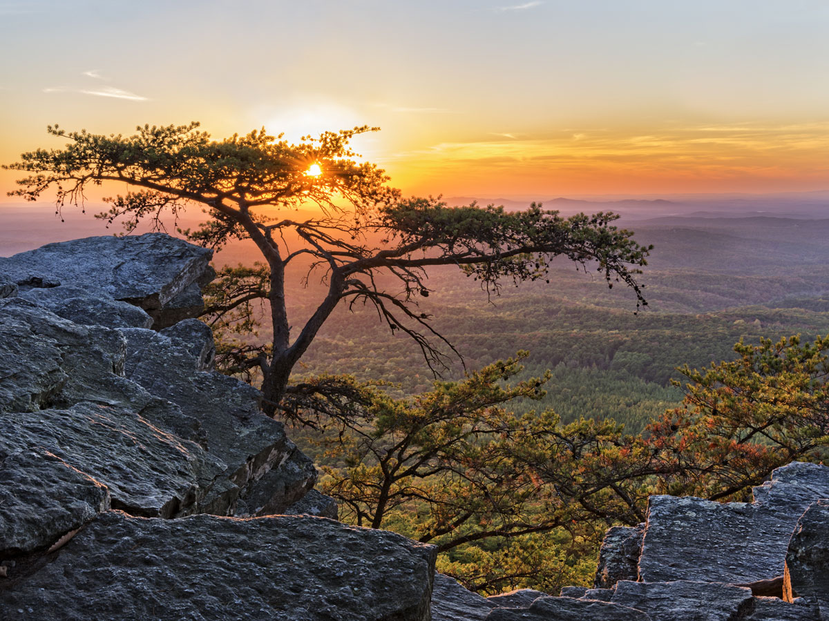
Cheaha State Park in Clay and Cleburne, Alabama is a 2,799-acre site named after the Cheaha Mountain, which is the highest point in the state. Part of the Talledega Mountains, the Cheaha Mountain provides a breathtaking view of the surrounding trees. It is made up of sandstone and Cheaha quartzite.
The park was first opened in 1933 and was worked on by the Civilian Conservation Corps that built a man-made lake and several structures in the area. However, currently, certain structures are closed down because of COVID-19. Usually, the park is extremely family-friendly and even includes playgrounds. Nearby you'll find the Talladega National Forest, several trails and bike paths.
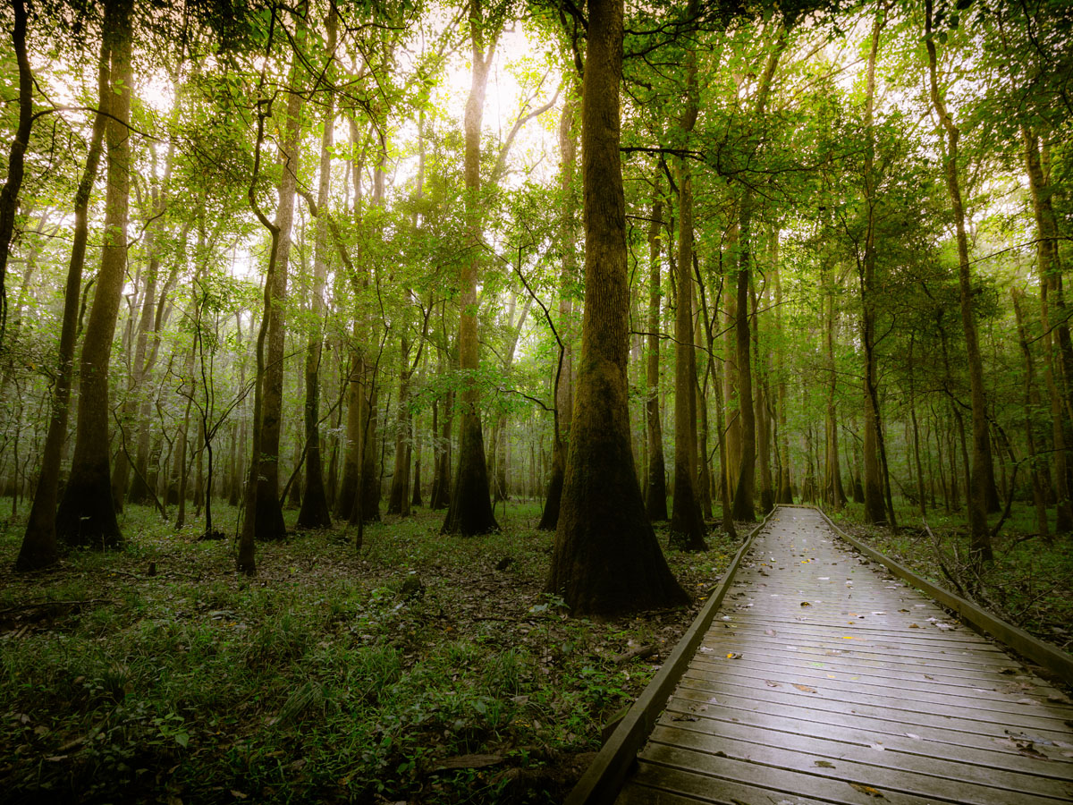
Congaree National Park is one of the most intriguing spots in South Carolina because of its colossal ancient hardwood forest. The sweeping stretches of trees take you deep into another world, away from civilization and cell phone reception. Extensive biodiversity in the area means you'll have a chance to see all sorts of birds and deer, raccoons, bobcats and more. The waters are inhabited by alligators, amphibians, snakes and fish.
The Congaree National Park features 15,000 acres of wilderness. While it has been used as far back as the 19th century, it became a national preserve in 1975 and then a National Park in 2003. Overall, the park encompasses 40.7 square miles. Camping, canoeing, and kayaking are popular activities.
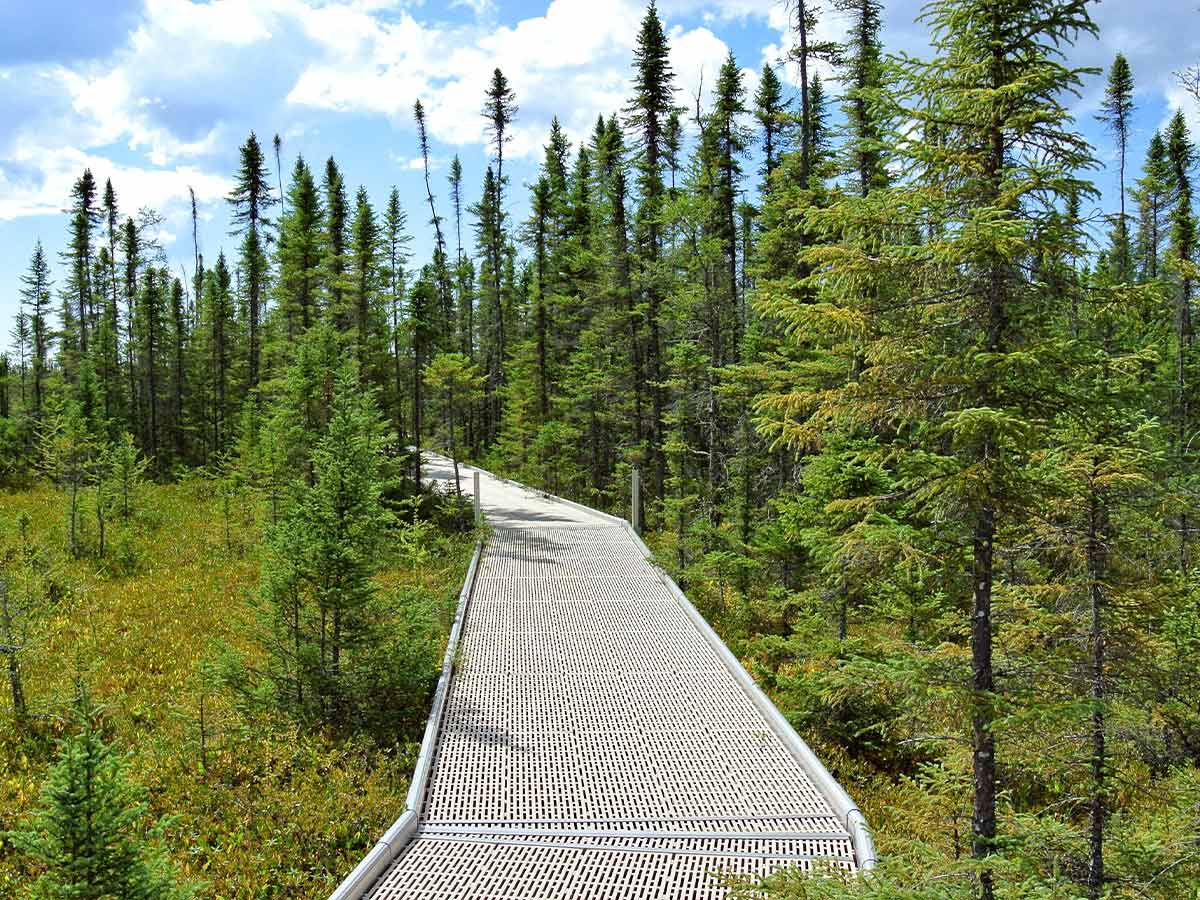
The Big Bog State Recreation Area is one of the newest areas of the Minnesota state park system and as such, it is a real gem. The area is comprised of wetlands with jackpine forests, nearby lakes and of course a big bog. The bog is about 500 square miles and is the largest in the southern states. It functions as a habitat for approximately 300 species of birds, white-tailed deer, black bears, gray wolves and other animals.
The park was started in 2002 and opened in 2006. Since then, the area is open to those interested in cabin camping, tent camping, and hiking. During the winter months, you can travel around in a snowmobile or walk with snowshoes. Thanks to a raised boardwalk that extends one mile, visitors can easily cross the bog. The boardwalk itself is designed to let in enough sunlight that it does not interfere with the growth of flora under it.
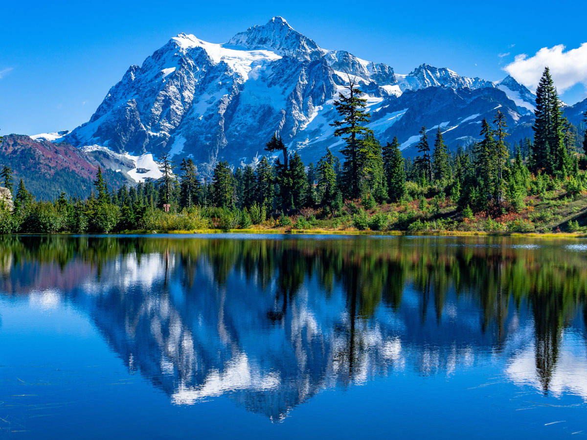
The Rocky Mountains are the biggest mountain range in the western United States. They stretch approximately 3,000 miles from northern part of British Columbia, all the way to New Mexico. While you can view the Rocky Mountains along any of this stretch, it is Colorado that offers the most jaw-dropping view of the Rockies.
The Rocky Mountain National Park in Colorado offers a magnificent view of the Rockies from Bear lake. The park is 415 square miles and protects the mountains. The 12,000-foot Trail Ridge Road overlooks the alpine forests. Meanwhile, there are over 300 miles of hiking trails to venture through with views of the vegetation and wildlife in the area. The park is also an excellent spot for gazing at the stars.
The Cave of the Mounds in Blue Mounds, Wisconsin is a natural limestone cave that has been designated a Natural National landmark since 1987. The limestone cave is believed to have started forming around 488 million years ago when the earth was covered in shallow seas. Over the course of millions of years, calcium carbonate shells from underwater organisms accumulated and began forming limestone.
The area of Blue Mounds is believed to be first settled by Europeans in 1828. Ebenezer Brigham, a Massachusetts miner, traveled to Wisconsin and set up a trade post. However, the cave itself was not discovered until 1939 when limestone quarry workers blasted a section of limestone that created an opening in the cave. Since then, the cave has attracted millions of visitors.
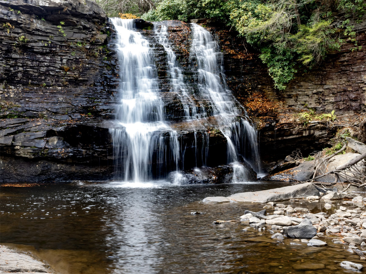
Muddy Creek Falls in Swallow Falls State Park is the highest free-falling waterfall in the state of Maryland at approximately 53 feet. Hemlock trees in the surrounding area of Muddy Falls are as much as 300 years old. During the winter months, the falls and the water below ice over. This waterfall is easily the biggest highlight of the park.
In addition to Muddy Creek, you can also check out smaller falls on the Youghiogheny River and Tolivar Creek. For nearly 100 years, the camp has been enjoyed by numerous visitors such as Henry Ford, Thomas Edison, and Harvey Firestone. The whole park spans 257 acres.
The Cuivre River is a 41.6-mile river located in eastern Missouri. It borders the counties of Lincoln and St. Charles. The Cuivre River was named by French settlers in French Louisiana. The name means copper which is strange because there is no actual copper present in the river. Thus, many believe the name comes from Baron Georges Leopold Cuvier, a French naturalist. Additionally, the River has historical significance since the mouth of the river was the site of a battle in the War of 1812.
Cuivre River State Park is one of the largest state parks in the state. It's also one of the most rugged which means you'll find the most authentic nature experience. Set up camp and hike the parks many trails. Fishing, horseback riding, canoeing and swimming are just some of the things you can do.
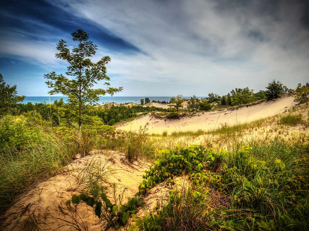
At the Indiana Dunes State Park you'll see marvelous sand dunes, beautiful beaches and green vegetation. The spacious park provides an ideal spot for relaxation with over 2,000 acres to explore. The park has welcomed visitors since 1925. Visitors can swim in Michigan lake, trek through three miles of sand dunes, while admiring all sorts of flora and fauna.
The beaches at Indiana Dunes were, of course, formed by Lake Michigan. During the Ice Age, the lake receded and formed new dunes along the shore. Meanwhile, the old dunes became a place for growing vegetation, turning into the lush forest you can see today.
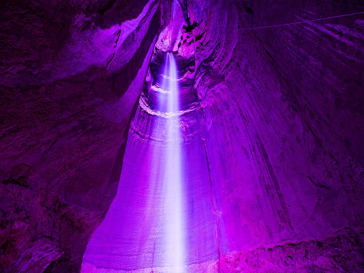
Ruby Falls in Tennessee is not your average waterfall. It is made up of a series of underground cascade waterfalls that are approximately 145 feet high. The deep underground cavern within Lookout Mountain is open to the public and has been since 1929. Prior to 1929, the cave had no available opening (the previous one was closed for railroad construction) until cave enthusiast Leo Lambert sought to create a new opening for Lookout Mountain.
Lambert drilled a new opening and began exploring the caves when then he stumbled upon Ruby Falls. The Ruby falls cave became so popular that the Lookout Mountain Cave was closed down. For those interested in seeing Ruby falls for yourself, it is recommended that you do not drink the water. While it is certainly safe to drink, the high magnesium content makes the water a natural laxative.
The Chesterfield Gorge is a stunning nature reserve in Chesterfield, Massachusetts. It is carved from metamorphic bedrock by melted glacier water and continues to open up thanks to the Westfield River. The gorge features deep walls that rise up to 30 feet high. The cliff edges do not feature any trails that go to the bottom but you can travel along the cliff top, which offers a terrific view of the gorge as well as the river and surrounding forest.
The Chesterfield Gorge encompasses 13 acres of land. Hiking is the main activity of interest for visitors as climbing is not allowed on the cliffs. Pets are allowed in certain designated areas. Of course, picnicking is also an option. So, if you are looking for a relaxing spot where you can appreciate the beauty of New England, Chesterfield Gorge is the ideal spot.

When talking about Arizona's natural wonders, it seems a little too obvious to name the Grand Canyon. In terms of size, it's certainly impressive, but in terms of wonder, Antelope Canyon takes the cake. Antelope Canyon is a nature photographer's dream. The smooth canyon walls with penetrating beams of light evoke feelings of awe and mystery.
The walls of Antelope Canyon are formed by the erosion of sandstone caused by flash floods, rain, and other environmental factors. That's why it is best to avoid visiting Antelope Canyon during monsoon season. Nevertheless, the best time to view the canyon is in the summer if you hope to catch a glimpse of the sunbeams. Tours of the canyon are available throughout the year.
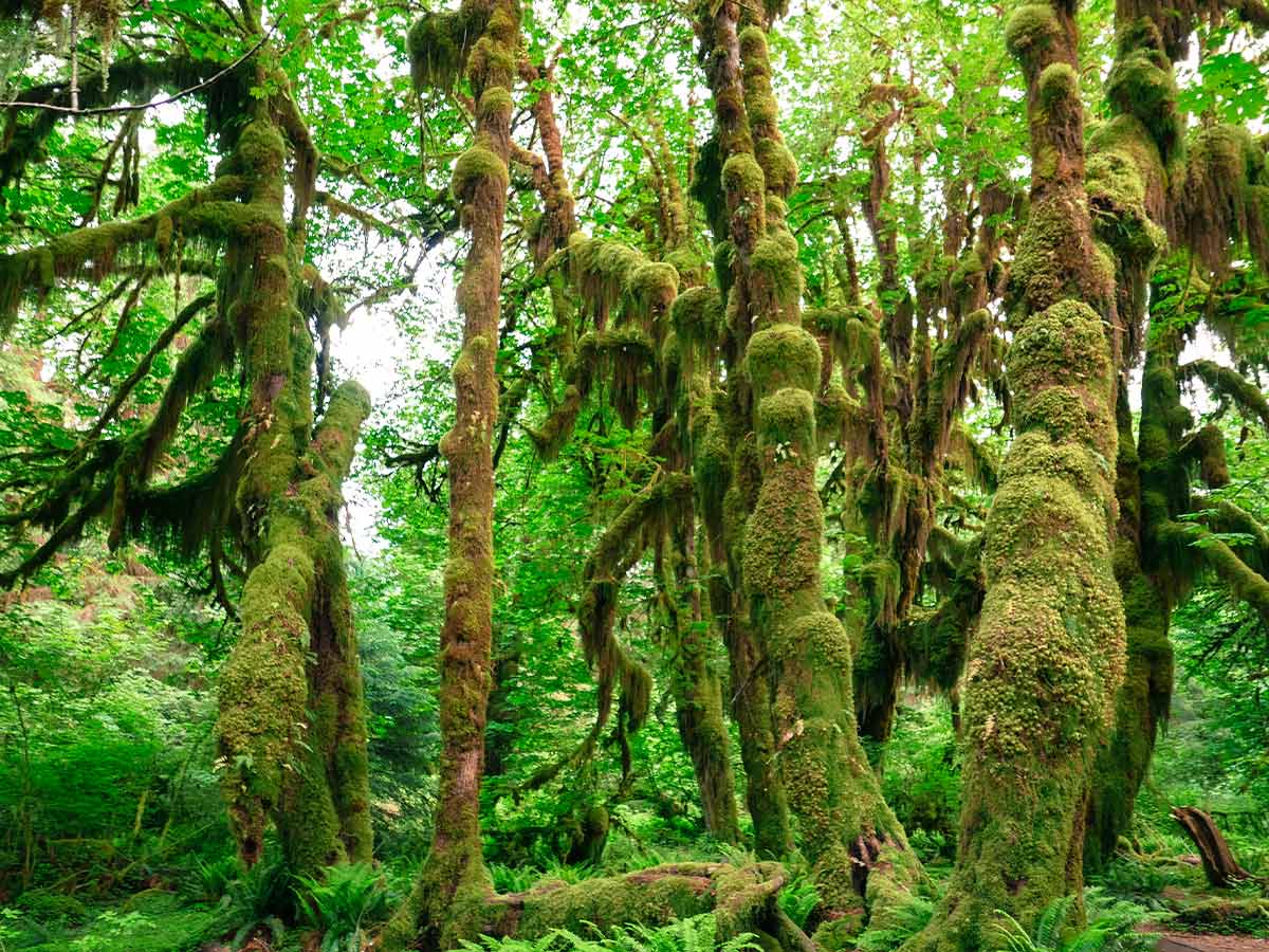
You don't have to travel to the Amazon to see a real rainforest. The H Rainforest in Washington is one of the largest temperate rainforests in the United States. As part of the Olympic National Park, the H Rainforest is protected from commercial interference and exploitation. Unfortunately, much of the rainforest has been cut down. Nevertheless, there is still much to see with over 24 miles of low elevation rainforest allocated along the H River.
The rainforest features a variety of trees, including Sitka spruces, western hemlocks, bigleaf maples, western red cedar and Coast Douglas-fir trees. Among the animals that inhabit the area are the northern spotted owl, Pacific tree frog, and Olympic black bear. The rainforest gets most of its rain during the winter but still gets rain throughout the year, producing the lush green forest that inspires visitors from all over.

Great Falls on the Potomac River is easily among the most alluring sites in the east. Located 14 miles upstream from Washington D.C, you can view Great Falls in Fairfax County, Virginia. Great Falls Park offers scenic views of Great Falls and the Potomac. The rocks of the area are an estimated 750 million years old and the Great Falls themselves formed nearly 35,000 years ago as the sea level dropped.
Great Falls Park offers more than just a waterfall. While you could probably take in the view of the waterfalls for hours, you can also engage in activities such as boating, bird watching, fishing, cycling, hiking and climbing. Horseback riding in the area is also popular with ten miles of trails. Offering 800 stunning acres, there's so much to see and do.
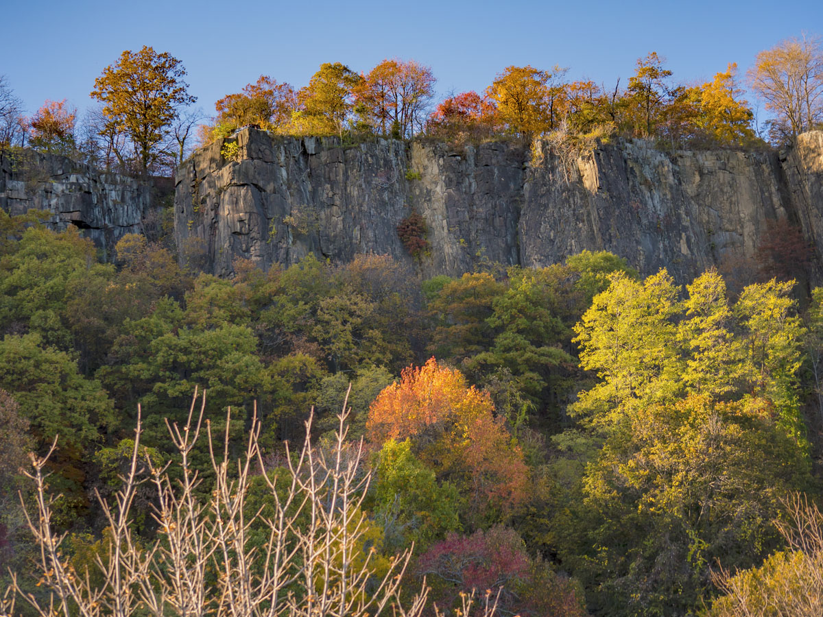
The Palisades along the Hudson River in New Jersey are the most astonishing sight in the state. The Palisades are a steep line of cliffs that’s stretch 20 miles from Jersey City to Nyack, New York. Located at the edge of the River, the cliffs are an astounding 300 feet high in most parts but go up to a whopping 540 feet in other parts.
Formed some 200 million years ago, basalt cliffs are believed to have been formed by magma intrusion in sandstone. The existence of the cliffs has been known to Europeans as far back as 1541 where it appeared on a map made by renowned geographer and cartographer, Gerardus Mercator. Today the Palisades are protected by the Palisades Interstate Park Commission, which was created in response to its continued destruction by quarry operators in the 19th century. In 1983, the Palisades were proclaimed a National Natural Landmark.
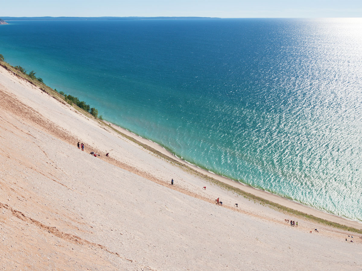
Sleeping Bear Dunes National Lakeshore is located along the northwest coast of the Lower Peninsula of Michigan. The park is approximately 35 miles long and spans 71,187 acres. Established in 1970, the park's creation caused controversy at first because it turned private properties into public property. Those with homes in the area are now located on Sleeping Bear Dunes National Lakeshore.
The area features lush, green forests, crystal-clear inland lakes, and tons of unique wildlife and plant life. Activities you can participate in are camping, biking, hiking, boating, and swimming. In the winter you can ski or snowshoe.

The Pisgah National Forest in the Appalachian Mountains of North Carolina is contained entirely in the state. Established in 1916, it was one of the very first national forests. The area measures 512,758 acres. Within its borders are mile-high mountain peaks, huge slopes of forest, cascading waterfalls, and whitewater rivers.
The Pisgah forest offers a wide variety of trails through hardwood forests, camping and picnic areas, as well as river fishing. Mountain climbing and mountain biking are also allowed but are only recommended for experts as the area is a high risk, offering some of the toughest biking trails in the country.

Lookout Mountain offers a picturesque view of the Georgian landscape below. The city in which the mountain rests sits entirely in Walker County. Lookout Mountain features a spectacular view with a waterfall and pool right on the side of the cliff. Although swimming there is not recommended.
The most popular landmark at Lookout Mountain would have to be Sunset Rock, which has not only a great view but historical significance. An available trail takes you to this point and is a favorite among tourists. Civil War enthusiasts will especially appreciate the site as it was used in 1863 as a lookout for Confederate troops to track Union movement in the area.
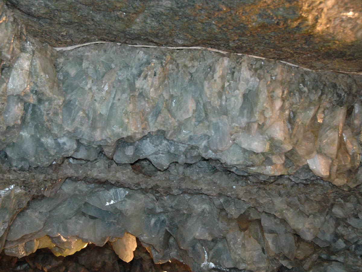
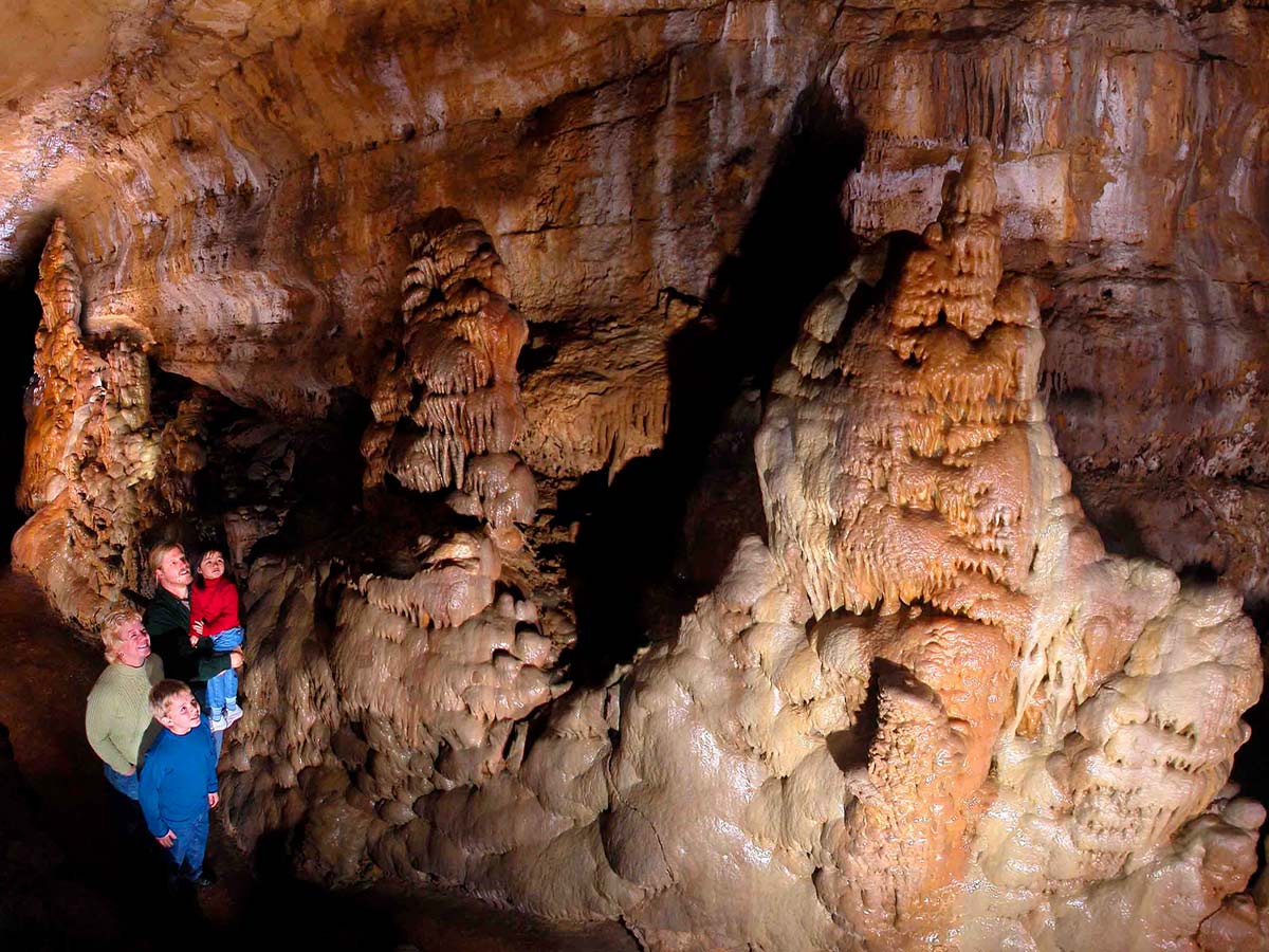
Crystal Cave in Put-in-Bay, Ohio is a limestone cave discovered by German immigrant Gustav Heineman in 1897. Digging a well underneath his winery, he discovered a cave filled will large celestine crystals. For a time, the celestine would be used to produce red fireworks. He then stopped the mining and turned the cave into a tourist spot, which helped him make a living during prohibition.
Today, you can enjoy the comforts of wine and the beauty of the cave. The crystals are still very much present and make up the world's largest known geode. So, take a fascinating tour of the site and take home some wine to celebrate, or have some wine first and then take the tour, just be sure not to get too unruly.
Starved Rock State Park is the biggest attraction in the state of Illinois. It features 13 miles of trails and numerous seasonal waterfalls that are especially active in the spring. With a total of 18 canyons, there are many places to explore. Available activities in the area include camping, boating, fishing and hiking.
The name Starved Rock is derived after a Native American legend in which the Pontiac and the Illinois tribes fought one another in a great battle after the Pontiac chief was stabbed at a council meeting. The surviving Illinois fled to the area that is now Starved Rock, and as the name suggests, there they died of starvation. It's not the happiest of stories but Starved Rock is truly a wondrous sight.

Believe it or not, there's more than one Grand Canyon in the country. The Pennsylvania Grand Canyon, unlike the one in Arizona, is brimming with life. Also known as Pine Creek Gorge, the Pennsylvania Grand Canyon stretches for over 50 miles and is up to 1,000 feet deep. Trees in the area are bountiful and look particularly amazing in the fall.
Protected as a Natural Area in the state of Pennsylvania and as a Natural Landmark, the area totals over 12,00 acres. In the past it has served as a travel route for Native Americans and in the 19th century it became a significant source of lumber. Fortunately, the forests have regrown since and plenty of animals inhabit the area, including bald eagles.
When most people think of New York, they think of the city, but outside that the state is rich in vegetation and natural wonders. The Andirondack Mountains in New York are proof of that. Covering about 5,000 square miles, the exquisite mountains feature sweeping forests and over 200 surrounding lakes. Mountain summits rise as high as 5,000 feet or more.
Humans have inhabited the area as far back at 15,000 BC and today there are 100 different communities spread out over 6 Million acres of land. Visitors in the area can engage in birdwatching, cycling, kayaking, and hiking. Otherwise, you can take a scenic drive and set up camp at any one of the numerous sites in the area.
In the tropical wetlands of Florida, the Everglades offers the largest subtropical wilderness in the country. The rare habitat is home to a variety of endangered species such as the Florida panther, American crocodile and manatee. The weather is unlike any other with frequent flooding during the wet season and drought in the dry season. The total area of the Everglades is 7,800 square miles.
The Everglades is welcome to visitors. Cycling is a common interest in the area. Boating, kayaking and canoeing are also popular activities. Bird watchers will especially love the Everglades as it is home to the great blue heron, roseate spoonbill and the great egret – just to name a few. On top of this, you can hike various short or long trails in the area, so there's a little something for everyone.

The Palo Duro Canyon in Texas is a glorious sight that offers a rugged terrain and peaceful solitude. It is the second-largest canyon in the United States but that hardly makes it second best. At 120 miles long and 20 miles wide in some areas, the canyon is huge. Formed by the Prairie Dog Town Fork Red River, water erosion has played a significant role in the canyon's formation.
Humans have inhabited the land as far back as 15,000 years ago but the first European explorers to discover the canyon found it in 1541. The land would eventually become privately owned and not available to the public again until 1931. By 1934, the land was purchased by the State of Texas and would become the Palo Duro Canyon State Park. Today, backpackers and horse riders flock to Palo Duro Canyon for a true western adventure.
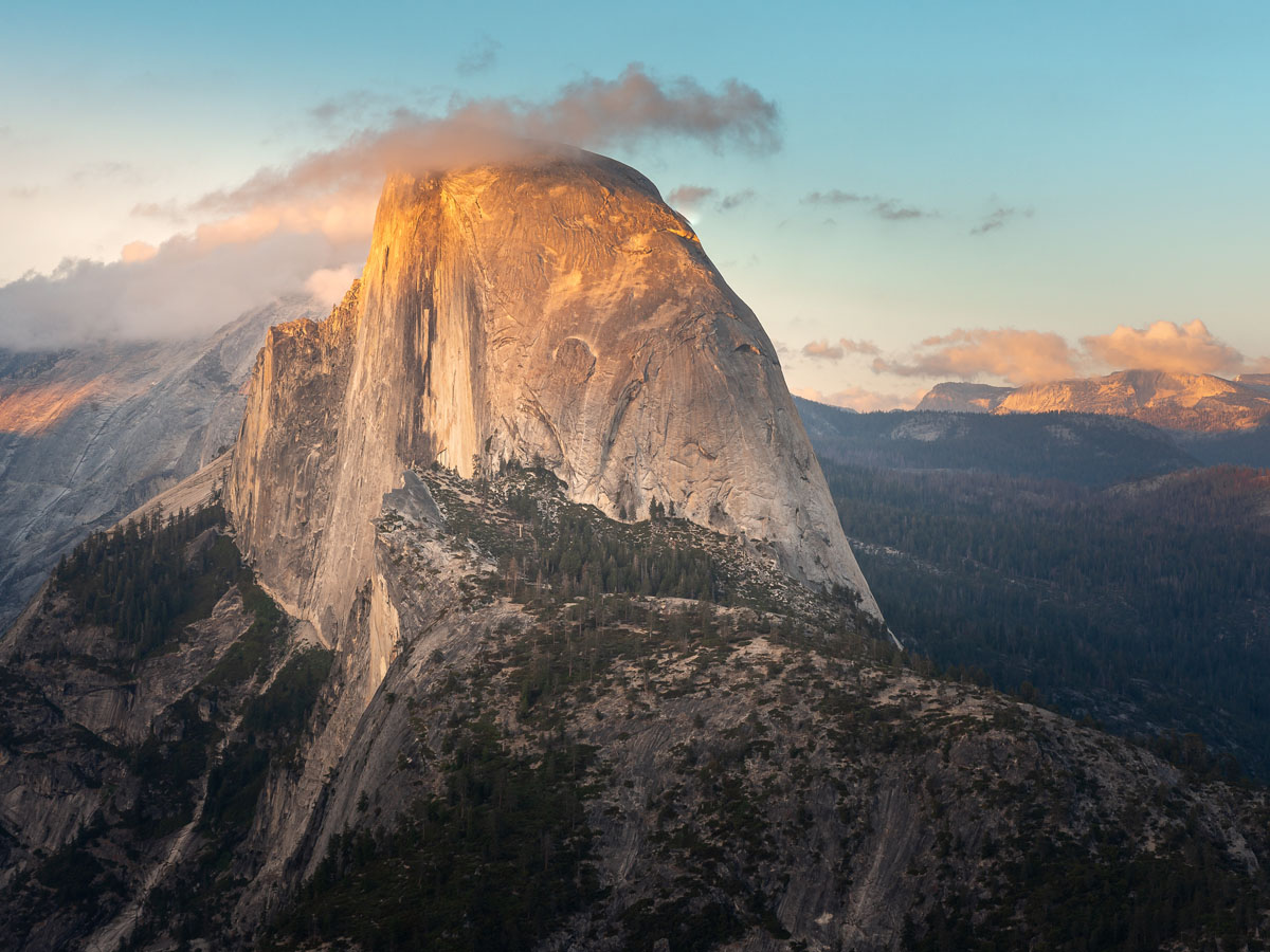
There are many beautiful places to visit in the state of California, but Yosemite is the best of the best. The massive national park extends into Tuolumne, Mariposa, Mono, and Madera counties, and covers about 1,169 square miles. The majesty of Yosemite is well-recognized internationally. Visitors from all over the world come to the park to take in its colossal granite cliffs, sequoia groves and mountains. It also features lakes, rivers, streams and monumental waterfalls.
If there is one spot in North America that encapsulates everything alluring about the continent's landscape, then Yosemite is that place. Travelers come to Yosemite to get in touch with nature and embark on an unforgettable adventure into the wilderness. Camping, biking, and backpacking are just some of the things you can do. If you are looking for the best natural wonders in the country, you'll find a lot more than one at Yosemite.